

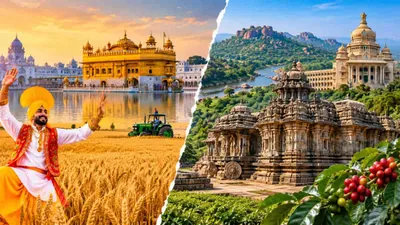
Separated by more than 2,000 kilometers, Punjab in the northwest and Karnataka in the south showcase the immense diversity of the Indian subcontinent. While one serves as the nation’s historic granary, anchored by alluvial soils and heavy farm mechanization, the other operates as a global technology powerhouse with a complex landscape of rain-forested mountains, coastal waters, and high-altitude plateaus.
Examining their core attributes reveals how contrasting environments have shaped entirely distinct socio-economic engines.
At a Glance: Comparative Overview
| Dimension | Punjab | Karnataka |
| Zone / Location | Northwestern India | Southern India |
| Capital | Chandigarh (jointly shared) | Bengaluru |
| Geographic Area | 50,362 sq km | 1,91,791 sq km (~3.8× larger) |
| Population (Census 2011) | 27,743,338 | 61,095,297 |
| Districts | 23 | 31 |
| Literacy Rate (Census 2011) | 75.84% | 75.36% |
| Primary River Systems | Sutlej, Beas, Ravi (Indus Basin) | Krishna, Cauvery, Tungabhadra, Sharavathi |
| Dominant Topography | Alluvial Indo-Gangetic Plains & Shivalik fringe | Deccan Plateau, Western Ghats, Coastal Plains |
| Climate Profile | Semi-arid to Subtropical (extreme seasonal variance) | Tropical Monsoonal to Semi-Arid |
| Core Agricultural Focus | Wheat, Paddy, Cotton (staple food grain production) | Coffee, Ragi, Pulses, Spices, Horticulture |
| Technological & Industrial Core | Farm mechanization, light manufacturing, agro-processing | Enterprise IT, Biotech, Aerospace, Agritech |
Area and Demographics
Karnataka is significantly larger in terms of physical territory, encompassing 1,91,791 sq km compared to Punjab’s 50,362 sq km. Karnataka accounts for roughly 5.8% of India’s total land area, making it nearly four times the size of Punjab.
This geographic scale directly affects population size:
- Punjab: Recorded a population of 2.77 crore (2011 Census) distributed over 23 administrative districts. Because of its relatively compact land area, it maintains a higher population density (~551 people/sq km), supported by an even spread of agricultural settlements and tier-2 urban centers like Ludhiana, Amritsar, and Jalandhar.
- Karnataka: Home to 6.11 crore people (2011 Census) spread across 31 districts. The state’s population density sits lower (~319 people/sq km), but it features heavy urbanization concentrated in the Greater Bengaluru metropolitan area alongside vast, sparsely populated rural belts in the arid north and dense Western Ghats.
Capitals and Administrative Centers
The administrative capitals of both states reflect different architectural and economic stories:
- Chandigarh (Punjab): Serving as a Union Territory and the joint capital for both Punjab and Haryana, Chandigarh is world-renowned for its mid-century modern architecture and urban master plan created by Swiss-French architect Le Corbusier. It serves primarily as an administrative, educational, and judicial nerve center.
- Bengaluru (Karnataka): Originally renowned as the “Garden City,” Karnataka’s capital has transformed into the “Silicon Valley of India.” It serves as the primary engine for software exports, deep-tech research centers, venture capital investment, and aerospace engineering in South Asia.
Geography and River Systems
Punjab: The Alluvial Basin
Punjab derives its historical name from the Persian Panj (five) and Aab (water). While the historic Punjab spanned five major rivers of the Indus basin (Sutlej, Beas, Ravi, Chenab, and Jhelum), modern Indian Punjab is drained primarily by the Sutlej, Beas, and Ravi.
The terrain is virtually flat, formed by millions of years of rich alluvial silt deposited by Himalayan meltwater rivers. Aside from the northeastern Shivalik foothill strip, almost the entire state consists of gentle gradients that allow for extensive canal networks and intensive cultivation.
Karnataka: A Tri-Zone Landscape
Karnataka’s geography is divided into three distinct physiographic zones:
- Karavali (Coastal Belt): A narrow coastal plain sandwiched between the Arabian Sea and the Western Ghats, characterized by sandy alluvium, estuaries, and heavy tropical precipitation.
- Malenadu (Hill Country): The jagged Western Ghats escarpment, rich in evergreen rainforests, wildlife sanctuaries, and high-elevation plantations.
- Bayaluseeme (Plateau): The rolling Deccan Plateau, divided into North Karnataka (semi-arid black soil terrain) and South Karnataka (red loamy soils).
Karnataka’s hydrology is split into east-flowing rivers (Krishna, Cauvery, Tungabhadra) that carve across the plateau toward the Bay of Bengal, and short, steep west-flowing rivers (Sharavathi, Netravati) that power massive hydroelectric projects, including the famous Jog Falls.
Climate Profiles
The contrasting latitudes and topographies generate two completely different weather regimes:
- Punjab (Subtropical Continental): Characterized by wide temperature swings. Winters (December to February) are sharply cold, with night temperatures dropping to 2°C–5°C due to Western Disturbances. Summers (May to June) bring extreme heat, with mercury regularly touching 40°C–46°C before the South-West Monsoon brings moderate rainfall between July and September.
- Karnataka (Tropical to Semi-Arid): Moderated by oceanic breezes and elevation. Coastal areas face hot, humid conditions with extreme monsoon rainfall exceeding 3,000–4,000 mm annually. In contrast, the interior Deccan plateau experiences a semi-arid, rain-shadow climate prone to periodic dry spells, while hill regions like Coorg and Chikmagalur enjoy year-round cool, temperate mountain conditions.
Agriculture: Breadbasket vs. Plantation & Millets
Agriculture is a foundational pillar for both states, yet their crop profiles and methods diverge based on soil types and hydrology.
Punjab Focus:       [ Wheat ] ➔ [ Paddy ] ➔ [ Cotton / Mustard ]
Karnataka Focus:    [ Coffee / Spices ] ➔ [ Millets / Ragi / Jowar ] ➔ [ Pulses / Sugarcane ]
- Punjab (High-Input Monoculture): As the epicenter of India’s Green Revolution in the 1960s, Punjab adopted high-yielding seed varieties, heavy chemical fertilizers, and double-cropping dominated by a wheat-paddy rotation. It contributes a disproportionately high share of wheat and rice to the central procurement pool for national food security.
- Karnataka (Crop Plurality & Plantations): Karnataka leads India in the production of coffee (over 70% of national output from Kodagu, Chikkamagaluru, and Hassan) and is a top producer of ragi (finger millet), jowar, sunflower, arecanut, and silk. Unlike Punjab’s grain-heavy focus, Karnataka’s agriculture is heavily geared toward dryland horticulture, pulses, spices, and commercial plantation crops.
Technology and Industrial Adaptation
Both states are technological leaders, but their applications align with their economic foundations:
Farm Machinery vs. Digital Innovation
- Punjab: Leads the nation in on-field farm mechanization. It has one of the highest tractor densities per hectare, alongside widespread use of combine harvesters, laser land levelers, and specialized seed drills (such as Happy Seeders and Super SMS units). Its traditional industries focus on light engineering, textile manufacturing (Ludhiana), sports equipment (Jalandhar), and food processing.
- Karnataka: Operates as a global IT, biotechnology, and venture-capital hub. Its technology sector powers cloud computing, artificial intelligence, software services, and space technologies (headquarters of ISRO). Within agriculture, Karnataka focuses on digital agritech platforms, satellite-guided drip and micro-irrigation systems, soil sensors, and precision biotechnology rather than solely heavy machinery.
Environmental and Resource Management Challenges
- Punjab: Faces acute groundwater depletion caused by power-subsidized tube wells that tap deep aquifers for water-thirsty summer paddy. It also tackles post-harvest stubble burning (crop residue management), which impacts seasonal air quality across North India.
- Karnataka: Faces frequent drought vulnerability in its northern arid districts (the second-largest dryland area in India after Rajasthan) and inter-state river water sharing disputes (Cauvery and Krishna basins). Its focus centers on watershed management, tank rejuvenation, and drought-tolerant farming systems.
Summary of Roles in India’s Economy
Punjab and Karnataka demonstrate how geographical setting directs economic specialization. Punjab’s flat plains and Himalayan rivers formed the backbone of India’s post-independence food security, setting benchmarks for agricultural output and mechanical adoption. Simultaneously, Karnataka’s varied topography and plateau climate enabled both high-value plantation ecosystems and the modern service, aerospace, and IT sectors that drive the country’s knowledge economy.