

The Lifeline of Northeast Africa: Discovering the Continent’s Longest River
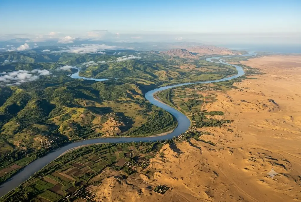
The Nile River holds the definitive title as the longest river in Africa and is historically recognized as the longest river system on Earth. Carving a path through arid deserts, tropical highlands, and dense wetlands, the river drains north into the Mediterranean Sea, covering roughly 10% of the entire African landmass.
For millennia, the Nile has served as a cultural, ecological, and economic artery—nourishing ancient empires, shaping modern geopolitical dynamics, and providing freshwater, fertile silt, and hydroelectric energy to hundreds of millions of people.
The Length of the Nile
Measuring the exact length of long river systems involves tracking the most distant seasonal headwaters, which leads to varying estimates depending on hydrological measurement methodologies.
- Standard Geographic Measurement: The Nile is most widely cited as being approximately 6,650 kilometers (4,132 miles) in length.
- Alternative Survey Figures: Some satellite and hydrological surveys trace its furthest headwaters to give figures between 6,695 km and 6,853 km (4,160 to 4,258 miles).
- Drainage Basin Extent: The Nile Basin encompasses approximately 3.3 million square kilometers, supporting over 250 million people.
| Feature | Key Specification |
| River Name | Nile River (An-Nīl) |
| Official Length | ~6,650 km (4,132 miles) |
| Flow Direction | South to North |
| Outflow / Mouth | Mediterranean Sea (Nile Delta, Egypt) |
| Major Tributaries | White Nile, Blue Nile, and the Atbara River |
| Highest Water Volume Source | Ethiopian Highlands (Blue Nile) |
The Source: Tracing the Two Niles
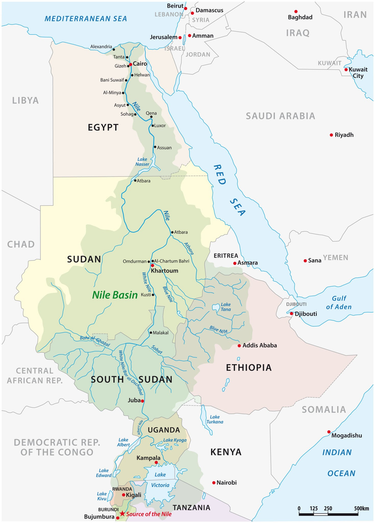
Pinpointing the singular origin of the Nile was one of the greatest geographic quests in history. In reality, the river is formed by the convergence of two major branches at Khartoum, Sudan: the White Nile and the Blue Nile.
1. The White Nile (Headwaters and Length)
The White Nile provides a steady, year-round base flow.
- Primary Reservoir: Lake Victoria—bordered by Uganda, Kenya, and Tanzania—is traditionally considered the primary source and principal reservoir of the White Nile.
- Most Distant Source: The most distant feeder streams lie further south in the equatorial highlands of Central Africa. Geographers trace the ultimate source to either the Kagera River, fed by headstreams in the Nyungwe Forest of Rwanda, or the Ruvyironza (Luuvyironza) River in the Bururi Province of Burundi.
- From Lake Victoria, the river exits as the Victoria Nile in Uganda, flows through Lake Kyoga and Lake Albert, enters South Sudan as the Mountain Nile (Bahr al-Jabal), traverses the vast Sudd swamps, and proceeds northward to Sudan.
2. The Blue Nile (Volume and Power)
While shorter, the Blue Nile contributes the overwhelming majority of the total water volume and fertile sediment.
- Origin: The Blue Nile originates in the Ethiopian Highlands at Lake Tana.
- Contribution: During the summer monsoon season (June to September), the Blue Nile and the nearby Atbara River supply over 80% of the Nile’s total flow downstream into Sudan and Egypt.
At Khartoum, the sluggish, light-tinted waters of the White Nile merge with the rapid, silt-rich torrent of the Blue Nile to form the main stem of the Nile River.
Countries of the Nile Basin
The Nile Basin includes 11 sovereign nations, collectively organized under the multilateral Nile Basin Initiative (NBI).
While the main navigable trunk flows directly through countries like South Sudan, Sudan, and Egypt, the remaining basin states contain essential headwater tributaries, lakes, and catchment areas.
- Burundi: Origin of the southernmost tributary streams (Ruvyironza) feeding the Kagera River.
- Rwanda: Headwaters in the high-altitude montane forests feeding into Lake Victoria.
- Tanzania: Holds substantial shoreline along Lake Victoria and feeds the Kagera drainage basin.
- Uganda: Home to the outlet of Lake Victoria (Jinja) and major internal waterways including Lake Kyoga and Lake Albert.
- Kenya: Direct drainage into Lake Victoria through rivers such as the Mara and Nzoia.
- Democratic Republic of the Congo (DRC): Encompasses Lake Edward and Lake Albert watershed networks draining toward the White Nile system.
- Ethiopia: The water tower of the basin, providing the headwaters for the Blue Nile, Baro-Akobo-Sobat, and Tekezé-Atbara systems.
- Eritrea: Contributes seasonal runoff via the Tekezé/Atbara river basin.
- South Sudan: Hosts the expansive Sudd wetland ecosystem, where the river winds before heading north.
- Sudan: The junction point where the Blue Nile and White Nile unite in Khartoum, and where the Atbara River joins.
- Egypt: The terminus of the river, where it fans out across the fertile Nile Delta into Damietta and Rosetta branches before entering the Mediterranean Sea.
Ecological and Strategic Significance
The Nile River is more than a geographic landmark; it is a critical natural lifeline:
- Agricultural Security: Over 95% of Egypt’s population lives within a few kilometers of the Nile banks and delta, relying almost exclusively on its waters for irrigation in an otherwise hyper-arid desert climate.
- Hydroelectric Power: Major infrastructure projects along the basin—including Egypt’s Aswan High Dam, Uganda’s Bujagali Dam, and Ethiopia’s Grand Ethiopian Renaissance Dam (GERD)—supply essential renewable power across East and Northeast Africa.
- Biodiversity: The river supports diverse ecosystems ranging from equatorial rainforests and papyrus swamps to arid riverbanks, serving as a sanctuary for hundreds of bird species, freshwater fish, and the Nile crocodile.
Frequently Asked Questions (FAQ): The Longest River in Africa
What is the longest river in Africa?
The Nile River is the longest river in Africa and is historically recognized as the longest river in the world. It flows northward through northeastern Africa and drains into the Mediterranean Sea.
Exactly how long is the Nile River?
The Nile River is most widely recorded at approximately 6,650 kilometers (4,132 miles). Depending on the measurement of its most distant seasonal headwaters using modern satellite hydrology, some estimates place its length between 6,695 km and 6,853 km.
What are the two main branches that form the Nile River?
The Nile is formed by the convergence of two major rivers:
- The White Nile: The longer tributary that provides a continuous, steady year-round base flow.
- The Blue Nile: The shorter tributary that carries the vast majority of the water volume and nutrient-dense silt.
They meet at Khartoum, the capital city of Sudan, to form the main stem of the Nile.
Where is the source of the Nile River?
Because the Nile has two major tributaries, it has two distinct primary source regions:
- White Nile Source: Traditionally traced to Lake Victoria, which is fed by headstreams extending as far south as the Nyungwe Forest in Rwanda and the Ruvyironza River in Burundi via the Kagera River system.
- Blue Nile Source: Originates in the Ethiopian Highlands at Lake Tana.
Which branch contributes the most water to the Nile?
The Blue Nile provides approximately 80% to 85% of the river’s total annual water volume, particularly during the summer monsoon season (June to September). The White Nile supplies the remaining steady base flow throughout the rest of the year.
How many countries are part of the Nile River Basin?
There are 11 countries within the Nile River Basin, collectively known through the Nile Basin Initiative (NBI):
- Burundi
- Rwanda
- Tanzania
- Uganda
- Kenya
- Democratic Republic of the Congo (DRC)
- Ethiopia
- Eritrea
- South Sudan
- Sudan
- Egypt
In which direction does the Nile River flow?
Unlike many of the world’s most prominent rivers, the Nile flows from south to north. It originates in high-elevation equatorial highlands and flows downward toward sea level at the Mediterranean Sea.
Where does the Nile River end?
The Nile empties into the Mediterranean Sea in northern Egypt via a vast, fertile wetland area called the Nile Delta, splitting into two primary distributaries: the Damietta branch to the east and the Rosetta branch to the west.
Why was the Nile River so vital to ancient and modern civilizations?
- Annual Inundation & Silt: Historically, seasonal flooding deposited mineral-rich black silt (kemet) along the arid banks, enabling fertile agriculture in the Sahara desert.
- Freshwater Security: Over 95% of Egypt’s population resides directly along the river’s banks and delta, relying on it for drinking water, domestic use, and irrigation.
- Renewable Energy: Major hydroelectric dams—such as Egypt’s Aswan High Dam and Ethiopia’s Grand Ethiopian Renaissance Dam (GERD)—generate significant electrical power for the region.